Pacer Walking App
The #1 Walking App
4.8
(1643K)
Open in App
Walking App
Near Me
Clubs
Challenges
Medals
For Workplaces
© Mapbox
© OpenStreetMap
Improve this map
© Mapbox
© OpenStreetMap
Improve this map
France
Auvergne-Rhône-Alpes
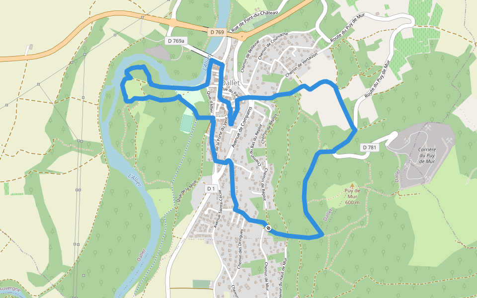
Mur-sur-Allier
從阿列到穆爾山
阿列河畔穆爾,奧弗涅-羅納-阿爾卑斯大區
France
Auvergne-Rhône-Alpes
Mur-sur-Allier
從阿列到穆爾山
1
評價
路線長度
5.8 公里
累計爬升
136 m
步數
8500
路線簡介
從阿列到穆爾山是一條位於阿列河畔穆爾,奧弗涅-羅納-阿爾卑斯大區的步道,他的長度為5.8km (大約8,500步) ,爬升高度為136m,難度評級中等。用Pacer App發現更多優質路線吧!
在應用中打開詳情
地圖
© Mapbox © OpenStreetMap
打開地圖
打開地圖
Last updated: Apr 1, 2025
路線簡介
路線長度
5.8 公里
累計爬升
136 m
步數
8500
推薦路線
达莱,多姆山省,法國
菩提樹
路線長度 8.2 公里
垂直,奧弗涅-羅納-阿爾卑斯大區
穆爾山周圍
路線長度 13.7 公里
· 爬升 321 m
默泽,多姆山省,法國
梅澤爾城堡
路線長度 9.1 公里
· 爬升 235 m
默泽,多姆山省,法國
城堡街
路線長度 3 公里
· 爬升 90 m
阿列河畔穆爾,奧弗涅-羅納-阿爾卑斯大區
阿列爾
路線長度 5.3 公里
庫爾農多韋爾尼,多姆山省,法國
庫農-德奧弗涅水域
路線長度 1.5 公里
Pacer Walking App
Pacer is the
best walking app
for walking challenges and finding
places to walk near me
.
在應用中打開詳情
取消
是
Pacer Walking App
The #1 Walking App
4.8
(1643K)
Open in App
Walking App
Near Me
Walking Clubs
Walking Challenges
Medals
For Workplaces