Pacer Walking App
The #1 Walking App
4.8
(1643K)
Open in App
Walking App
Near Me
Clubs
Challenges
Medals
For Workplaces
© Mapbox
© OpenStreetMap
Improve this map
© Mapbox
© OpenStreetMap
Improve this map
France
Auvergne-Rhône-Alpes
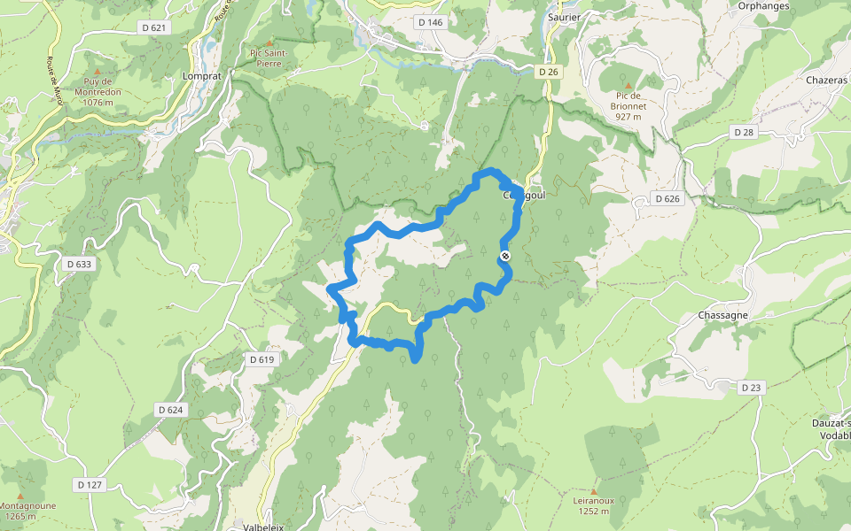
Courgoul
狼踪
瓦爾貝萊克斯,奧弗涅-羅納-阿爾卑斯大區
France
Auvergne-Rhône-Alpes
Courgoul
狼踪
1
評價
路線長度
11.8 公里
累計爬升
481 m
步數
17000
路線簡介
狼踪是一條位於瓦爾貝萊克斯,奧弗涅-羅納-阿爾卑斯大區的步道,他的長度為11.8km (大約17,000步) ,爬升高度為481m,難度評級困難。用Pacer App發現更多優質路線吧!
在應用中打開詳情
地圖
© Mapbox © OpenStreetMap
打開地圖
打開地圖
Last updated: Apr 1, 2025
路線簡介
路線長度
11.8 公里
累計爬升
481 m
步數
17000
推薦路線
庫古爾,奧弗涅-羅納-阿爾卑斯大區
牧羊女之路
路線長度 7.2 公里
· 爬升 403 m
庫古爾,奧弗涅-羅納-阿爾卑斯大區
索勒斯和帕伊哈茨之間
路線長度 2.3 公里
· 爬升 55 m
聖迪埃里,奧弗涅-羅納-阿爾卑斯大區
克呂澤爾峰之旅
路線長度 7.7 公里
· 爬升 301 m
Randonnée du plateau de la Chavade et de la Roche de Nité
路線長度 1.2 公里
· 爬升 56 m
庫古爾,奧弗涅-羅納-阿爾卑斯大區
烏塞爾高原
路線長度 6.4 公里
· 爬升 90 m
Chemin des Sources
路線長度 1 公里
· 爬升 3 m
Pacer Walking App
Pacer is the
best walking app
for walking challenges and finding
places to walk near me
.
在應用中打開詳情
取消
是
Pacer Walking App
The #1 Walking App
4.8
(1643K)
Open in App
Walking App
Near Me
Walking Clubs
Walking Challenges
Medals
For Workplaces