Pacer Walking App
The #1 Walking App
4.8
(1643K)
Open in App
Walking App
Near Me
Clubs
Challenges
Medals
For Workplaces
© Mapbox
© OpenStreetMap
Improve this map
© Mapbox
© OpenStreetMap
Improve this map
Denmark
North Denmark Region
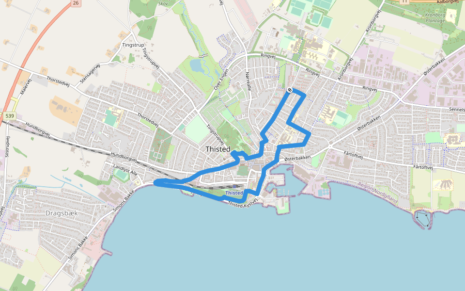
Thisted
Rød Kløversti,Thisted - Skovstien
提斯泰德
Denmark
North Denmark Region
Thisted
Rød Kløversti,Thisted - Skovstien
1
评价
路线长度
7.9 公里
累计爬升
10 米
步数
11000
路线简介
Rød Kløversti,Thisted - Skovstien是一条位于提斯泰德的步道,他的长度为7.9km (大约11,000步) ,爬升高度为10m,难度评级简单 。用Pacer App发现更多优质路线吧!
在应用中打开详情
地图
© Mapbox © OpenStreetMap
打开地图
打开地图
Last updated: Mar 1, 2025
路线简介
路线长度
7.9 公里
累计爬升
10 米
步数
11000
推荐路线
提斯泰德
Grøn Kløversti, Thisted - 向日葵小径
路线长度 2.5 公里
· 爬升 9 米
提斯泰德
黑色 Kløversti,Thisted - Strandstien
路线长度 10.1 公里
· 爬升 36 米
提斯泰德
Blå Kløversti, Thisted - Digterstien
路线长度 5.3 公里
· 爬升 16 米
Tingstrup Sø Stien
路线长度 1.2 公里
· 爬升 6 米
提斯泰德,北日德兰大区
利姆峡湾
路线长度 2.3 公里
Vestergade
路线长度 0.3 公里
Pacer Walking App
Pacer is the
best walking app
for walking challenges and finding
places to walk near me
.
在应用中打开详情
取消
是
Pacer Walking App
The #1 Walking App
4.8
(1643K)
Open in App
Walking App
Near Me
Walking Clubs
Walking Challenges
Medals
For Workplaces