Pacer Walking App
The #1 Walking App
4.8
(1643K)
Open in App
Walking App
Near Me
Clubs
Challenges
Medals
For Workplaces
© Mapbox
© OpenStreetMap
Improve this map
© Mapbox
© OpenStreetMap
Improve this map
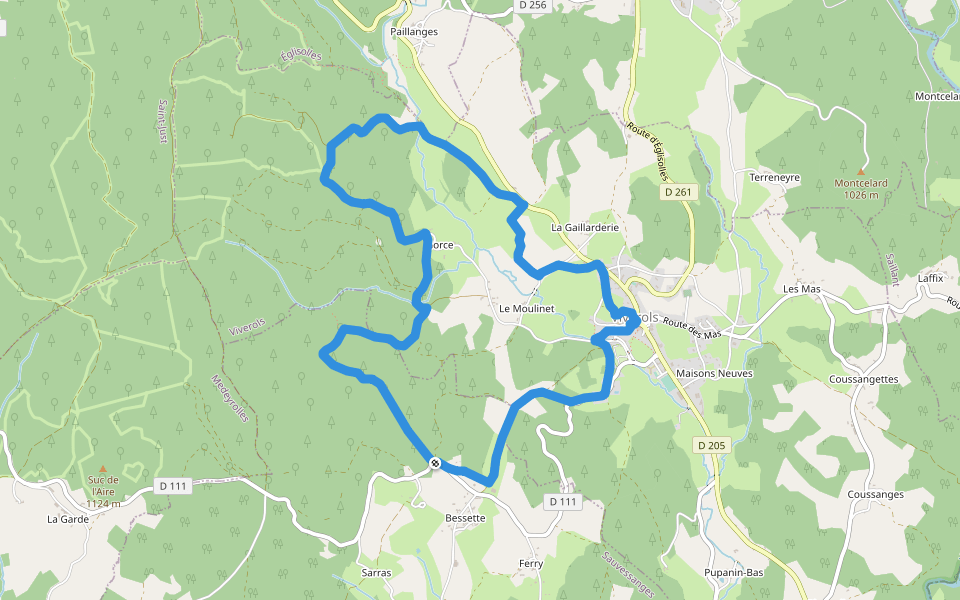
France
Auvergne-Rhône-Alpes
Medeyrolles
上阿尔宗河谷
梅代罗勒斯,奥弗涅-罗纳-阿尔卑斯大区
France
Auvergne-Rhône-Alpes
Medeyrolles
上阿尔宗河谷
1
评价
路线长度
8.8 公里
累计爬升
82 米
步数
13000
路线简介
上阿尔宗河谷是一条位于梅代罗勒斯,奥弗涅-罗纳-阿尔卑斯大区的步道,他的长度为8.8km (大约13,000步) ,爬升高度为82m,难度评级中等 。用Pacer App发现更多优质路线吧!
在应用中打开详情
地图
© Mapbox © OpenStreetMap
打开地图
打开地图
Last updated: Apr 1, 2025
路线简介
路线长度
8.8 公里
累计爬升
82 米
步数
13000
推荐路线
多雷教堂,奥弗涅-罗纳-阿尔卑斯大区
Dore l'Eglise 的全景
路线长度 17.2 公里
· 爬升 423 米
伯里埃,奥弗涅-罗纳-阿尔卑斯大区
蒙特拉维尔
路线长度 11.2 公里
· 爬升 346 米
维韦罗尔斯,奥弗涅-罗纳-阿尔卑斯大区
利戈讷
路线长度 9.4 公里
· 爬升 170 米
索维桑热,奥弗涅-罗纳-阿尔卑斯大区
索韦萨内勒斯
路线长度 9 公里
· 爬升 200 米
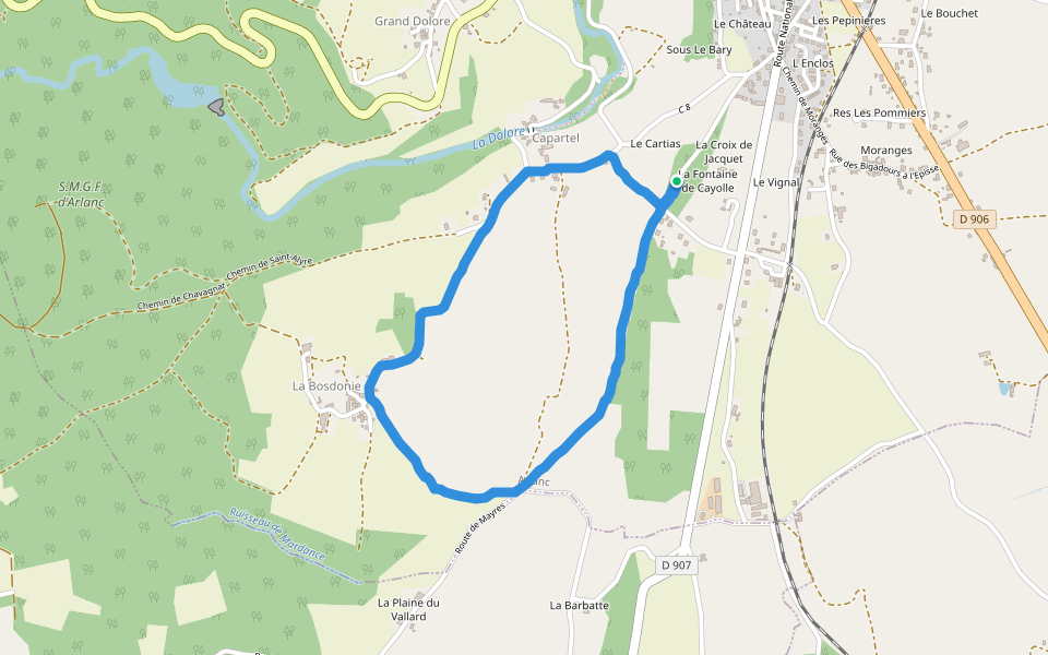
阿尔朗,多姆山省,法国
圣阿里尔之路
路线长度 3.3 公里
· 爬升 86 米
圣茹斯特,奥弗涅-罗纳-阿尔卑斯大区
水的故事
路线长度 8.9 公里
· 爬升 320 米
Pacer Walking App
Pacer is the
best walking app
for walking challenges and finding
places to walk near me
.
在应用中打开详情
取消
是
Pacer Walking App
The #1 Walking App
4.8
(1643K)
Open in App
Walking App
Near Me
Walking Clubs
Walking Challenges
Medals
For Workplaces