Pacer Walking App
The #1 Walking App
4.8
(1643K)
Open in App
Walking App
Near Me
Clubs
Challenges
Medals
For Workplaces
© Mapbox
© OpenStreetMap
Improve this map
© Mapbox
© OpenStreetMap
Improve this map
Denmark
North Denmark Region
Thisted
Rød Kløversti, Thisted - Skovstien
Thisted
Denmark
North Denmark Region
Thisted
Rød Kløversti, Thisted - Skovstien
1
reviews
Length
4.9 mi
Elev. Gain
32.8 ft
Est. Steps
11000
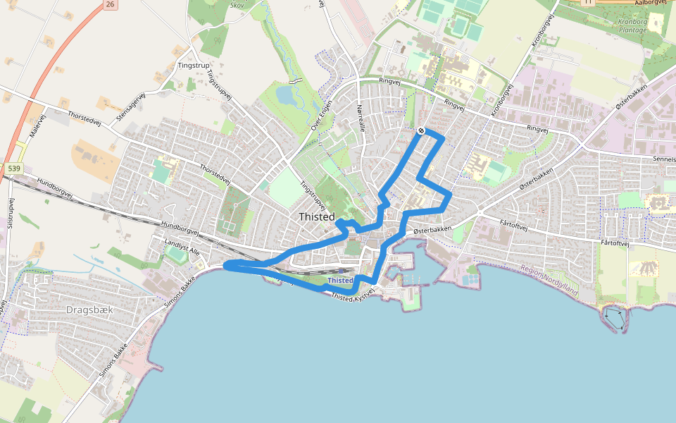
Rød Kløversti, Thisted - Skovstien Introduction
Rød Kløversti, Thisted - Skovstien is a 4.9 mile (11,000-step) route located near Thisted. This route has an elevation gain of about 32.8 ft and is rated as easy. Find the best walking trails near you in Pacer App.
Open in App for Details
Map of Rød Kløversti, Thisted - Skovstien
© Mapbox © OpenStreetMap
View Full Map
View Full Map
Last updated: Mar 1, 2025
Route Details
Length
4.9 mi
Elev. Gain
32.8 ft
Est. Steps
11000
Recommended Routes Near Rød Kløversti, Thisted - Skovstien
Thisted
Grøn Kløversti, Thisted - Sunflower Trail
Length 1.5 mi
· Elev 29.5 ft
Thisted
Black Kløversti, Thisted - Strandstien
Length 6.3 mi
· Elev 118.1 ft
Thisted
Blå Kløversti, Thisted - Digterstien
Length 3.3 mi
· Elev 52.5 ft
Thisted, North Denmark Region
Tingstrup Sø Stien
Length 0.7 mi
· Elev 19.7 ft
Thisted, North Denmark Region
The Limfjord
Length 1.4 mi
Thisted, North Denmark Region
Vestergade
Length 0.2 mi
Pacer Walking App
Pacer is the
best walking app
for walking challenges and finding
places to walk near me
.
Open in App for Details
Cancel
Yes
Pacer Walking App
The #1 Walking App
4.8
(1643K)
Open in App
Walking App
Near Me
Walking Clubs
Walking Challenges
Medals
For Workplaces