Pacer Walking App
The #1 Walking App
4.8
(1643K)
Open in App
Walking App
Near Me
Clubs
Challenges
Medals
For Workplaces
© Mapbox
© OpenStreetMap
Improve this map
© Mapbox
© OpenStreetMap
Improve this map
Denmark
North Denmark Region
Hanstholm
Hanstholm - red route
Hanstholm
Denmark
North Denmark Region
Hanstholm
Hanstholm - red route
1
reviews
Length
0.7 mi
Elev. Gain
101.7 ft
Est. Steps
1500
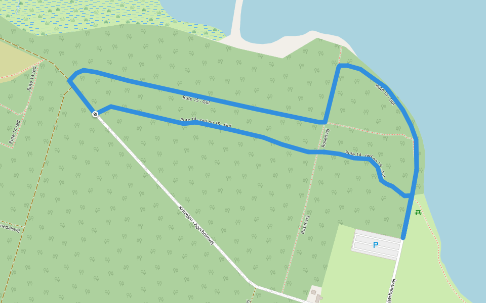
Hanstholm - red route Introduction
Hanstholm - red route is a 0.7 mile (1,500-step) route located near Hanstholm. This route has an elevation gain of about 101.7 ft and is rated as easy. Find the best walking trails near you in Pacer App.
Open in App for Details
Map of Hanstholm - red route
© Mapbox © OpenStreetMap
View Full Map
View Full Map
Last updated: Mar 1, 2025
Route Details
Length
0.7 mi
Elev. Gain
101.7 ft
Est. Steps
1500
Recommended Routes Near Hanstholm - red route
Hanstholm, North Denmark Region
Nordre Strandvej
Length 0.6 mi
Hanstholm, North Denmark Region
Vigsø Sti
Length 2.9 mi
· Elev 52.5 ft
Thisted, North Denmark Region
Rute 15 - Gul
Length 0.8 mi
· Elev 26.2 ft
Thisted
The Vilsbøl route
Length 4.4 mi
· Elev 111.5 ft
Thisted
Nebelruten
Length 1.5 mi
· Elev 23 ft
Thisted, North Denmark Region
Rute 14 - rød og 15 - Gul
Length 0.5 mi
· Elev 9.8 ft
Pacer Walking App
Pacer is the
best walking app
for walking challenges and finding
places to walk near me
.
Open in App for Details
Cancel
Yes
Pacer Walking App
The #1 Walking App
4.8
(1643K)
Open in App
Walking App
Near Me
Walking Clubs
Walking Challenges
Medals
For Workplaces