Open in App
pacer logo
park
walking near me in Santa Rosa and San Jacinto Mountains National Monument in winterwalking near me in Santa Rosa and San Jacinto Mountains National Monument in winter
walking near me in Santa Rosa and San Jacinto Mountains National Monument in winter
See All Photos

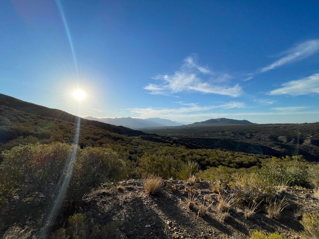
Santa Rosa and San Jacinto Mountains National Monument in Mountain Center | Map and Routes

Kid-friendly · Sports Facility · Heath · Scrub

4.9 (1537 ratings)

The Santa Rosa and San Jacinto Mountains National Monument, located in Mountain Center, offers an awe-inspiring expanse of natural beauty, covering 279970.2 acres. With its diverse landscape and a variety ...

The Santa Rosa and San Jacinto Mountains National Monument, located in Mountain Center, offers an awe-inspiring expanse of natural beauty, covering 279970.2 acres. With its diverse landscape and a variety of trails, this park is a haven for walkers and hikers of all levels. Whether you are seeking a leisurely stroll or a challenging hike, this park has something to suit every activity level. From the gentle slopes of the South Ridge Trail to the more rugged terrain of the Wild Horse Trail, there are options for all types of outdoor enthusiasts. The park's numerous routes provide opportunities to explore the stunning scenery and diverse ecosystems, making it an ideal destination for nature lovers and adventure seekers alike. As walkers and hikers venture through the Santa Rosa and San Jacinto Mountains National Monument, they will encounter an array of picturesque landscapes, from lush forests to rocky ridges, showcasing the park's natural wonders. The trails within the park offer a chance to immerse oneself in the tranquility of nature while engaging in physical activity. With routes like the Cathedral Trail and the Wild Horse Trail, visitors can enjoy a sense of serenity and adventure as they traverse the breathtaking surroundings. Whether embarking on a short, brisk walk or a longer, more challenging hike, the park's diverse trails cater to a range of preferences, promising an enriching and invigorating outdoor experience. For those seeking detailed information about the park's routes and additional walking/hiking activities, the Pacer Pedometer app provides a convenient resource for exploring the various trails and obtaining valuable insights. Visitors can download the app to access comprehensive park and route information, including trail lengths, estimated times, and user reviews, enhancing their overall park experience. With its blend of natural splendor and engaging walking/hiking opportunities, the Santa Rosa and San Jacinto Mountains National Monument in Mountain Center is an ideal destination for walkers and hikers looking to immerse themselves in the beauty of the great outdoors.

View MoreView More
Open in App for Detail
This park has a total of 79 photos
See All Photos
Overview
Check-in
Routes
Reviews (49)
Photos (79)

Walking and Hiking in Santa Rosa and San Jacinto Mountains National Monument

When visiting Mountain Center, United States, don't miss out on the breathtaking experience of walking and hiking in the Santa Rosa and San Jacinto Mountains National Monument. This park offers a wide range of essential amenities such as parking lots, restrooms, wheelchair-friendly facilities, drinking water, and picnic sites, making it ...

When visiting Mountain Center, United States, don't miss out on the breathtaking experience of walking and hiking in the Santa Rosa and San Jacinto Mountains National Monument. This park offers a wide range of essential amenities such as parking lots, restrooms, wheelchair-friendly facilities, drinking water, and picnic sites, making it a convenient and comfortable destination for walkers and hikers. Additionally, sports enthusiasts can enjoy facilities like tennis courts, horse riding, golf courses, swimming pools, and bowls courts. The park also provides accessibility for individuals with disabilities, ensuring that everyone can partake in the outdoor activities. As you explore the park, be sure to visit the various viewpoints, archaeological sites, and attractions such as the Palm Springs Aerial Tramway. With its diverse range of amenities and natural beauty, the Santa Rosa and San Jacinto Mountains National Monument is the ideal location for an unforgettable walking and hiking adventure.

View MoreView More

Other Info about Santa Rosa and San Jacinto Mountains National Monument

Essential Amenities in Santa Rosa and San Jacinto Mountains National Monument

phonePlayground
phonePicnic Site
phoneBBQ
phoneDrinking water
phoneWheelchair friendly
phoneRestroom
phoneParking lot

Santa Rosa and San Jacinto Mountains National Monument Sport Facilities

phoneTennis court
phoneBowls pitch
phoneGolf courseinfo
phoneSwimming poolinfo
phoneHorse ridinginfo

Accessibility in Santa Rosa and San Jacinto Mountains National Monument

phoneWheelchair friendly

Things to See in Santa Rosa and San Jacinto Mountains National Monument

Attraction

Palm Springs Aerial Tramway

Viewpoint

Desert View

Viewpoint

Caramba Overlook

Viewpoint

Coachella Valley Vista

Viewpoint

Cahuilla Tewanet Scenic Overlook

Viewpoint

Notch 2

Viewpoint

Notch 3

Viewpoint

Notch 4

Viewpoint

Notch 1

Viewpoint

Grubb's Point

Viewpoint

Notch 5

Viewpoint

Simonetta Kennett viewpoint

Archaeological site

Cahuila Petroglyphs

Archaeological site

Early Indian Fish Traps

View More

Other Amenities in Santa Rosa and San Jacinto Mountains National Monument

Shelter

Restaurant

Best Walking Routes in Santa Rosa and San Jacinto Mountains National Monument

#1 - Santa Rosa and San Jacinto Mountains National Monument
24
Length: 2.9 milesEst. Time: 50m

Santa Rosa and San Jacinto Mountains National Monument is a 2.9 mile (6,500-step) route located near Palm Desert, California, USA. This route has an elevation gain of about 0 ft and is rated as easy. Find the best walking trails near you in Pacer App.

#2 - Cahuilla Hills Park - Hopalong Cassidy Trail
7
Length: 3.4 milesEst. Time: 58m

Cahuilla Hills Park - Hopalong Cassidy Trail is a 3.4 mile (8,000-step) route located near Palm Desert, California, USA. This route has an elevation gain of about 829.8 ft and is rated as hard. Find the best walking trails near you in Pacer App.

#3 - Art Smith trail
6
Length: 2.9 milesEst. Time: 50m

Art Smith trail is a 2.9 mile (6,500-step) route located near Palm Desert, California, USA. This route has an elevation gain of about 793.8 ft and is rated as hard. Find the best walking trails near you in Pacer App.

See All Routes
See All Routes

Reviews of Santa Rosa and San Jacinto Mountains National Monument

4.9/5
1537 ratings
SShanahanJan 25, 2025
5

This a nice lake with a campground. It’s nice to walk around the lake getting g out there and enjoying the day.

sandidelic36Oct 19, 2020
5

Very thought mile and a half cake walk after

mtov1104May 28, 2020
4

&👩🏿‍🚀 USll

See All Reviews (49)

Santa Rosa and San Jacinto Mountains National Monument Leaderboard

RankingCheck-ins
Nadia
464
Alan
153
PacerPal
139
4Alan
49
5Japz1
47
6PacerPal
39
7danseg7667
33
8Nelson
29
9Teresa
26
10Cyndi
24
*Leaderboard only shows top 10 users. Only public activities are eligible for leaderboards. For any one park, a user can only check-in a maximum of once per day.
Nearby Parks
Ironwood Park
Washington Charter School Park
Palma Village Park
Civic Center Park
Rancho Mirage Community Park
Magnesia Falls City Park
La Quinta Community Park
Fritz Burns Park
La Quinta Civic Center Park

FAQs About Santa Rosa and San Jacinto Mountains National Monument

Where is the best place to walk in Santa Rosa and San Jacinto Mountains National Monument in Mountain Center, United States?

According to the Pacer community, the best places to walk in Santa Rosa and San Jacinto Mountains National Monument include the South Ridge Trail (3E08), Wild Horse Trail, and Cathedral Trail. These trails offer beautiful scenery and a variety of terrains for walkers and hikers to enjoy.

How many routes are in Santa Rosa and San Jacinto Mountains National Monument in Mountain Center, United States?

There are a total of six routes in Santa Rosa and San Jacinto Mountains National Monument, as per the Pacer community's information. These routes cater to different difficulty levels and distances, providing options for all types of walkers and hikers.

Which is the longest route in Santa Rosa and San Jacinto Mountains National Monument in Mountain Center, United States?

The longest route in Santa Rosa and San Jacinto Mountains National Monument is the Thursday exploration hike: Oasis 9, as per the information from the Pacer community. This trail spans 12.5 miles and offers a more challenging and lengthy hiking experience for enthusiasts.

Are there facilities or amenities for walkers/hikers in Santa Rosa and San Jacinto Mountains National Monument?

Yes, there are essential amenities such as parking lots, restrooms, wheelchair-friendly facilities, drinking water, and picnic sites available for walkers and hikers in the park.

How accessible is Santa Rosa and San Jacinto Mountains National Monument?

The park is wheelchair-friendly, ensuring accessibility for all visitors, including walkers and hikers.

What kind of sports can I do in Santa Rosa and San Jacinto Mountains National Monument?

While the park offers various sports facilities such as tennis courts, horse riding, golf courses, swimming pools, and bowls courts, the focus is more on walking, hiking, and enjoying the viewpoints and archaeological sites.

What is the best season to hike in Santa Rosa and San Jacinto Mountains National Monument?

The best season for hiking in Santa Rosa and San Jacinto Mountains National Monument is typically fall and spring. During these seasons, the weather is mild, and the landscapes are often at their most beautiful.

What are the typical weather conditions to prepare for in Santa Rosa and San Jacinto Mountains National Monument?

Visitors to Santa Rosa and San Jacinto Mountains National Monument should be prepared for a range of weather conditions. Summers can be hot and dry, while winters may bring snow at higher elevations. It's important to check the weather forecast before visiting and to dress in layers to accommodate changing temperatures.

What kind of wildlife might you encounter in Santa Rosa and San Jacinto Mountains National Monument?

Santa Rosa and San Jacinto Mountains National Monument is home to a diverse array of wildlife, including mule deer, bighorn sheep, mountain lions, and a variety of bird species. Visitors should be respectful of the natural habitats of these animals and be aware of their surroundings while hiking.

Last updated: Mar 27, 2025

Parks Near Santa Rosa and San Jacinto Mountains National Monument

walking in Ironwood Park map in Palm Desert
Ironwood Park
walking in Washington Charter School Park map in Palm Desert
Washington Charter School Park
walking in Palma Village Park map in Palm Desert
Palma Village Park
walking in Civic Center Park map in Palm Desert
Civic Center Park
Rancho Mirage Community Park
Magnesia Falls City Park
La Quinta Community Park
Fritz Burns Park
La Quinta Civic Center Park

Latest Check-ins at Santa Rosa and San Jacinto Mountains National Monument

AlanMar 27, 2025
Mar 27, 2025Hiking
NadiaMar 27, 2025
Mar 27, 2025Hiking
qqq229153Mar 27, 2025
Mar 27, 2025Running
NadiaMar 26, 2025
Mar 26, 2025Hiking
PacerPalMar 22, 2025
Mar 22, 2025Hiking
NadiaMar 25, 2025
Mar 25, 2025Hiking
CyndiMar 25, 2025
Mar 25, 2025Walking
NadiaMar 24, 2025
Mar 24, 2025Hiking
PacerPalMar 20, 2025
Mar 20, 2025Hiking
竹原 泰世Mar 22, 2025
Mar 22, 2025Walking
*Latest check-in only shows the last 10 users. Only public activities are eligible. For any one park, a user can only check-in a maximum of once per day.

Total Check-ins at Santa Rosa and San Jacinto Mountains National Monument

RankingCheck-ins
Nadia
464
Alan
153
PacerPal
139
4Alan
49
5Japz1
47
6PacerPal
39
7danseg7667
33
8Nelson
29
9Teresa
26
10Cyndi
24
*Leaderboard only shows top 10 users. Only public activities are eligible for leaderboards. For any one park, a user can only check-in a maximum of once per day.
Best Walking Routes in Santa Rosa and San Jacinto Mountains National Monument
#1- Santa Rosa and San Jacinto Mountains National Monument
24
Length: 2.9 milesEst. Time: 50m

Santa Rosa and San Jacinto Mountains National Monument is a 2.9 mile (6,500-step) route located near Palm Desert, California, USA. This route has an elevation gain of about 0 ft and is rated as easy. Find the best walking trails near you in Pacer App.

#2- Cahuilla Hills Park - Hopalong Cassidy Trail
7
Length: 3.4 milesEst. Time: 58m

Cahuilla Hills Park - Hopalong Cassidy Trail is a 3.4 mile (8,000-step) route located near Palm Desert, California, USA. This route has an elevation gain of about 829.8 ft and is rated as hard. Find the best walking trails near you in Pacer App.

#3- Art Smith trail
6
Length: 2.9 milesEst. Time: 50m

Art Smith trail is a 2.9 mile (6,500-step) route located near Palm Desert, California, USA. This route has an elevation gain of about 793.8 ft and is rated as hard. Find the best walking trails near you in Pacer App.

#4- Indio Mountain - Randall Henderson Trail
4
Length: 1.8 milesEst. Time: 31m

Indio Mountain - Randall Henderson Trail is a 1.8 mile (4,000-step) route located near Palm Desert, California, USA. This route has an elevation gain of about 396.9 ft and is rated as medium. Find the best walking trails near you in Pacer App.

#5- Homestead Trail
1
Length: 0.2 milesEst. Time: 4m

Homestead Trail is a 0.2 mile (500-step) route located near Palm Desert, California. This route has an elevation gain of about 0 ft and is rated as easy. Find the best walking trails near you in Pacer App.

#6- Bump and Grind (trail)
2
Length: 0.9 milesEst. Time: 42m

This is a moderate to difficult trail because the entire trail is ascending. For your serious cardio workouts? This is the trail, best to jog descending on this trail. The elevation gain is not to be taken lightly either! It appears over 1,500 feet. You’ll definitely need water and sun protection on this trail.

#7- Mike Schuler Trail
2
Length: 0.9 milesEst. Time: 36m

This is the trail behind Target in Palm Desert. Now noisy and annoying on the first 1/2 mile because of the remote control car race track adjacent on the west of the trailhead. This is a moderate hike and gets really steep on the last 1/2 before connecting to Bump and Grind.

#8- Bump and Grind Trail
1
Length: 3.4 milesEst. Time: 1h4m

Bump and Grind Trail is a 3.4 mile (8,000-step) route located near Palm Desert, California, USA. This route has an elevation gain of about 843 ft and is rated as hard. Find the best walking trails near you in Pacer App.

#9- Hopalong Cassidy
1
Length: 0.6 milesEst. Time: 21m

American movie and television cowboy hero, William Boyd, was a Palm Desert resident and known for giving his “Happy wooden nickels to children and teaching them his tips to good citizenship known as “Happy Creed.” The trail was dedicated on January 31, 2004 by his widow, Grace Bradley Boyd, saying that “Happy and Topper would have loved the trail and have encouraged everyone enjoy it and practice trail safety. Happy’s Creed: 1. The highest badge of honor a person can wear is honesty. Be truthful at all times.. 2. Your parents are the best friends you have. Listen to them and obey their instructions.. 3. If you want to be respected, you must respect others. Show good manners in every way. 4. Only through hard work and study can you succeed. Don’t be lazy... 5. Your good deeds always come to light. So don’t boast or be a show off. 6. If you waste time or money today, you will regret it tomorrow. Practice thrift in all ways. 7. Many animals are good and loyal companions. Be friendly and kind to them. 8. A strong, healthy body is a precious gift. Be neat and clean. 9. Our country’s laws are made for your protection. Observe them carefully. 10. Children in many foreign lands are less fortunate than you. Be glad and proud you are an American.

#10- South Ridge Trail (3E08)
1
Length: 1.5 milesEst. Time: 26m

South Ridge Trail (3E08) is a 1.5 mile (3,500-step) route located near Mountain Center, California. This route has an elevation gain of about 0 ft and is rated as easy. Find the best walking trails near you in Pacer App.

#11- Wild Horse Trail (Alternate)
1
Length: 0.7 milesEst. Time: 12m

Wild Horse Trail (Alternate) is a 0.7 mile (1,500-step) route located near Palm Springs, California. This route has an elevation gain of about 55.8 ft and is rated as easy. Find the best walking trails near you in Pacer App.

#12- Wild Horse Trail
1
Length: 4.1 milesEst. Time: 1h5m

Wild Horse Trail is a 4.1 mile (9,500-step) route located near Palm Springs, California. This route has an elevation gain of about 508.4 ft and is rated as medium. Find the best walking trails near you in Pacer App.

#13- Cathedral Trail
1
Length: 1.7 milesEst. Time: 30m

Cathedral Trail is a 1.7 mile (4,000-step) route located near Palm Springs, California. This route has an elevation gain of about 75.4 ft and is rated as easy. Find the best walking trails near you in Pacer App.

#14- Dry Wash Trail
1
Length: 3.1 milesEst. Time: 52m

Dry Wash Trail is a 3.1 mile (7,000-step) route located near Palm Springs, California. This route has an elevation gain of about 574 ft and is rated as medium. Find the best walking trails near you in Pacer App.

#15- Vandeventer Trail
1
Length: 1.9 milesEst. Time: 33m

Vandeventer Trail is a 1.9 mile (4,500-step) route located near Palm Springs, California. This route has an elevation gain of about 373.9 ft and is rated as medium. Find the best walking trails near you in Pacer App.

#16- Herb Jeffries Trail
1
Length: 1.3 milesEst. Time: 22m

Herb Jeffries Trail is a 1.3 mile (3,000-step) route located near Palm Desert, California. This route has an elevation gain of about 0 ft and is rated as easy. Find the best walking trails near you in Pacer App.

#17- Art Smith trail
1
Length: 7.7 milesEst. Time: 2h59m

Art Smith trail is a 7.7 mile (18,000-step) route located near Palm Desert, California. This route has an elevation gain of about 469 ft and is rated as medium. Find the best walking trails near you in Pacer App.

#18- Art Smith Trail
1
Length: 0.2 milesEst. Time: 4m

Art Smith Trail is a 0.2 mile (500-step) route located near Palm Desert, California. This route has an elevation gain of about 91.8 ft and is rated as hard. Find the best walking trails near you in Pacer App.

#19- Alexander Trail
1
Length: 0.8 milesEst. Time: 14m

Alexander Trail is a 0.8 mile (2,000-step) route located near Palm Springs, California. This route has an elevation gain of about 36.1 ft and is rated as easy. Find the best walking trails near you in Pacer App.

#20- Murray Canyon Trail
1
Length: 0.5 milesEst. Time: 8m

Murray Canyon Trail is a 0.5 mile (1,000-step) route located near Palm Springs, California. This route has an elevation gain of about 324.7 ft and is rated as hard. Find the best walking trails near you in Pacer App.

#21- Hahn Buena Vista
1
Length: 3.3 milesEst. Time: 56m

Hahn Buena Vista is a 3.3 mile (7,500-step) route located near Palm Springs, California. This route has an elevation gain of about 209.9 ft and is rated as easy. Find the best walking trails near you in Pacer App.

#22- Cedar Spring Trail
1
Length: 0.8 milesEst. Time: 14m

Cedar Spring Trail is a 0.8 mile (2,000-step) route located near Mountain Center, California. This route has an elevation gain of about 0 ft and is rated as easy. Find the best walking trails near you in Pacer App.

#23- Dunn Road Connector Trail
1
Length: 1.1 milesEst. Time: 19m

Dunn Road Connector Trail is a 1.1 mile (2,500-step) route located near Palm Springs, California. This route has an elevation gain of about 108.2 ft and is rated as easy. Find the best walking trails near you in Pacer App.

#24- Mike Schuler Trail
1
Length: 0.8 milesEst. Time: 14m

Mike Schuler Trail is a 0.8 mile (2,000-step) route located near Palm Desert, California. This route has an elevation gain of about 147.6 ft and is rated as medium. Find the best walking trails near you in Pacer App.

#25- Dead Indian Canyon
1
Length: 1.1 milesEst. Time: 18m

Dead Indian Canyon is a 1.1 mile (2,500-step) route located near Palm Desert, California. This route has an elevation gain of about 272.2 ft and is rated as medium. Find the best walking trails near you in Pacer App.

#26- East Fork Trail
1
Length: 1.6 milesEst. Time: 28m

East Fork Trail is a 1.6 mile (3,500-step) route located near Palm Springs, California. This route has an elevation gain of about 88.6 ft and is rated as easy. Find the best walking trails near you in Pacer App.

#27- Apache Spring Trail
1
Length: 0.5 milesEst. Time: 7m

Apache Spring Trail is a 0.5 mile (1,000-step) route located near Mountain Center, California. This route has an elevation gain of about 0 ft and is rated as easy. Find the best walking trails near you in Pacer App.

#28- Fern Canyon Trail
1
Length: 2.3 milesEst. Time: 38m

Fern Canyon Trail is a 2.3 mile (5,000-step) route located near Palm Springs, California. This route has an elevation gain of about 0 ft and is rated as easy. Find the best walking trails near you in Pacer App.

#29- Indian Potrero Trail
1
Length: 2.2 milesEst. Time: 37m

Indian Potrero Trail is a 2.2 mile (5,000-step) route located near Palm Springs, California. This route has an elevation gain of about 478.9 ft and is rated as medium. Find the best walking trails near you in Pacer App.

Reviews of Santa Rosa and San Jacinto Mountains National Monument

SShanahanJan 25, 2025
5

This a nice lake with a campground. It’s nice to walk around the lake getting g out there and enjoying the day.

sandidelic36Oct 19, 2020
5

Very thought mile and a half cake walk after

mtov1104May 28, 2020
4

&👩🏿‍🚀 USll

🇺🇸Ms.cruze83🫶🏽🧜🏽‍♀️🧚🏽🙊🙉🙈Jun 4, 2024
5

Great trail

DaisyJun 17, 2020
4

Pollo

CarlosFeb 1, 2025
5
CyndiJan 16, 2025
5
NelsonJan 9, 2025
5
竹原 泰世Jan 2, 2025
5
PacerGuy_1993Dec 21, 2024
5
PacerPalDec 16, 2024
5
PacerPalDec 2, 2024
5
melinda.sandersNov 16, 2024
5
MattNov 12, 2024
5
miriamromero051Aug 14, 2024
5
Carlos AbrilleAug 9, 2024
5
LourdesAug 6, 2024
5
PacerPalApr 4, 2024
5
PacerPalMar 29, 2023
5
CameronFeb 17, 2023
5
Letty MandujanoFeb 9, 2023
5
chubertNov 20, 2022
5
terryNov 11, 2022
5
NadiaNov 1, 2022
5
GGMay 15, 2022
5
RickMar 5, 2022
5
Elizabeth PFeb 22, 2022
5
PacerPalJan 17, 2022
5
chris.ruckel123Aug 27, 2021
5
Japz1Jul 25, 2021
5
AlanJun 27, 2021
5
MartijnMay 16, 2021
5
annaMar 19, 2021
5
famordieFeb 13, 2021
5
MariaFeb 2, 2021
5
hannahsmithgDec 24, 2020
5
PacerGal_1983Dec 13, 2020
5
DustinRAveryDec 13, 2020
5
christinaarroyo1982Oct 10, 2020
5
BlancaSep 26, 2020
5
JoseJun 28, 2020
5
PacerPalJun 17, 2020
5
TaniaJun 13, 2020
5
ChandraMay 15, 2020
5
erica_h07Mar 17, 2020
5
cllondoMar 12, 2025
4
HannahNov 10, 2020
4
everbenavides50Jun 28, 2020
4
PacerPalJun 19, 2020
4
4.9/5
1537 ratings

Photos of Santa Rosa and San Jacinto Mountains National Monument

pacer

Pacer Walking App

Pacer is the best walking app for walking challenges and finding places to walk near me.