Pacer Walking App
The #1 Walking App
4.8
(1643K)
Open in App
Walking App
Near Me
Clubs
Challenges
Medals
For Workplaces
© Mapbox
© OpenStreetMap
Improve this map
© Mapbox
© OpenStreetMap
Improve this map
Germany
Salzatal
하이킹 코스 6 Höhnstedt
Seegebiet 맨스펠더 랜드, 작센-안할트
Germany
Salzatal
하이킹 코스 6 Höhnstedt
1
평가
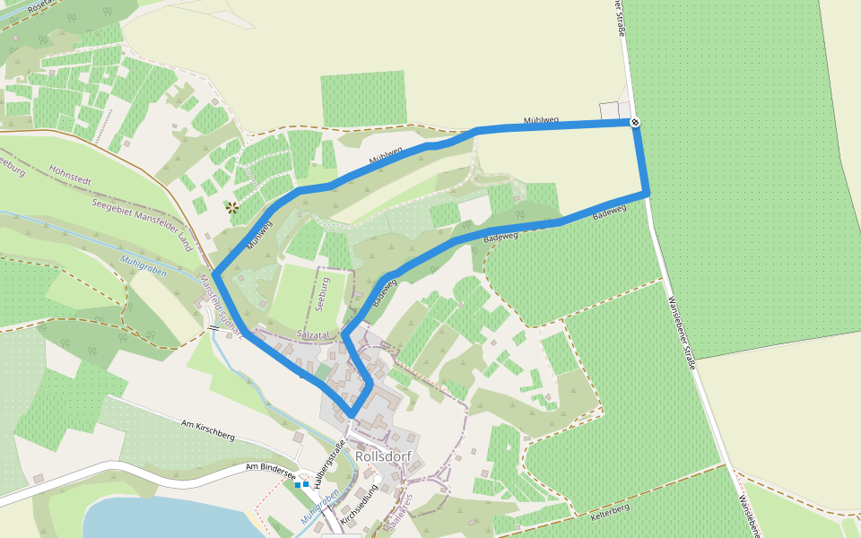
길이
7.2 km
고도 높이기
71 m
단계
10000
루트 디테일
하이킹 코스 6 Höhnstedt은/는 7.2 km (10,000-걸음) Seegebiet 맨스펠더 랜드, 작센-안할트주변 입니다. 이 루트의 경도는 대략 71 m 정도이며, 별점쉬움 점을 받았습니다. 이것과 비슷한 루트를 Pacer 앱 에서 찾아보세요!!
자세한 내용은 앱에서 열기
지도
© Mapbox © OpenStreetMap
전체 지도 보기
전체 지도 보기
Last updated: Apr 1, 2025
루트 디테일
길이
7.2 km
고도 높이기
71 m
단계
10000
추천 루트
살자탈, 작센-안할트
하이킹 코스 5 Höhnstedt
길이 3.4 km
· 경도 63 m
살자탈, 작센-안할트
하이킹 코스 4 Höhnstedt
길이 3.1 km
· 경도 1 m
Seegebiet 맨스펠더 랜드, 작센-안할트
횔슈테트 2
길이 6.8 km
· 경도 76 m
Seegebiet 맨스펠더 랜드, 작센-안할트
횔슈테트 롤스도르프
길이 2 km
살자탈, 작센-안할트
하이킹 코스 2 Höhnstedt
길이 4.7 km
· 경도 31 m
Egypten
길이 0.2 km
Pacer Walking App
Pacer is the
best walking app
for walking challenges and finding
places to walk near me
.
자세한 내용은 앱에서 열기
취소
예
Pacer Walking App
The #1 Walking App
4.8
(1643K)
Open in App
Walking App
Near Me
Walking Clubs
Walking Challenges
Medals
For Workplaces